All Projects
All Projects
All Projects
All Projects
2D vs. 2D+3D Maps: A Comparative Study on Route Planning
2D vs. 2D+3D Maps: A Comparative Study on Route Planning
2D vs. 2D+3D Maps: A Comparative Study on Route Planning
2D vs. 2D+3D Maps: A Comparative Study on Route Planning
2D vs. 2D+3D Maps: A Comparative Study on Route Planning

UX Research
Comparative Study
Thematic Analysis
User-Centered Design
HCI (Human Computer Interaction)
UX Research
Comparative Study
Thematic Analysis
User-Centered Design
HCI (Human Computer Interaction)
UX Research
Comparative Study
Thematic Analysis
User-Centered Design
HCI (Human Computer Interaction)
UX Research
Comparative Study
Thematic Analysis
User-Centered Design
HCI (Human Computer Interaction)
UX Research
Comparative Study
Thematic Analysis
User-Centered Design
HCI (Human Computer Interaction)
TEAM
TEAM
TEAM
TEAM
TEAM
Anshul Singh Jadone (UX Researcher)
Aki Matsunaga (UX Researcher)
Srijan Sarkar (Software Engineer)
Anshul Singh Jadone (UX Researcher)
Aki Matsunaga (UX Researcher)
Srijan Sarkar (Software Engineer)
Anshul Singh Jadone (UX Researcher)
Aki Matsunaga (UX Researcher)
Srijan Sarkar (Software Engineer)
Anshul Singh Jadone (UX Researcher)
Aki Matsunaga (UX Researcher)
Srijan Sarkar (Software Engineer)
Anshul Singh Jadone (UX Researcher)
Aki Matsunaga (UX Researcher)
Srijan Sarkar (Software Engineer)
LOCATION & YEAR
LOCATION & YEAR
LOCATION & YEAR
LOCATION & YEAR
LOCATION & YEAR
Paris, France - 2023
Paris, France - 2023
Paris, France - 2023
Paris, France - 2023
Paris, France - 2023
SUMMARY
SUMMARY
SUMMARY
SUMMARY
SUMMARY
This study investigates the effectiveness of using a combination of 2D and 3D map views for route planning and memorization, addressing the uncertainty surrounding the benefits of 3D maps for these tasks. In this study we:
This study investigates the effectiveness of using a combination of 2D and 3D map views for route planning and memorization, addressing the uncertainty surrounding the benefits of 3D maps for these tasks. In this study we:
This study investigates the effectiveness of using a combination of 2D and 3D map views for route planning and memorization, addressing the uncertainty surrounding the benefits of 3D maps for these tasks. In this study we:
This study investigates the effectiveness of using a combination of 2D and 3D map views for route planning and memorization, addressing the uncertainty surrounding the benefits of 3D maps for these tasks. In this study we:
This study investigates the effectiveness of using a combination of 2D and 3D map views for route planning and memorization, addressing the uncertainty surrounding the benefits of 3D maps for these tasks. In this study we:
Prototyped a web app: Utilized Google Maps API & Three.js to create 2D and 2D+3D map views.
User study to evaluate 2D+3D maps: Investigated effectiveness for route planning & memory, aiming to improve map applications.
Prototyped a web app: Utilized Google Maps API & Three.js to create 2D and 2D+3D map views.
User study to evaluate 2D+3D maps: Investigated effectiveness for route planning & memory, aiming to improve map applications.
Prototyped a web app: Utilized Google Maps API & Three.js to create 2D and 2D+3D map views.
User study to evaluate 2D+3D maps: Investigated effectiveness for route planning & memory, aiming to improve map applications.
Prototyped a web app: Utilized Google Maps API & Three.js to create 2D and 2D+3D map views.
User study to evaluate 2D+3D maps: Investigated effectiveness for route planning & memory, aiming to improve map applications.
Prototyped a web app: Utilized Google Maps API & Three.js to create 2D and 2D+3D map views.
User study to evaluate 2D+3D maps: Investigated effectiveness for route planning & memory, aiming to improve map applications.

INTRODUCTION
INTRODUCTION
INTRODUCTION
INTRODUCTION
INTRODUCTION
Exploring Map Views for Enhanced Route Planning
Exploring Map Views for Enhanced Route Planning
Exploring Map Views for Enhanced Route Planning
Exploring Map Views for Enhanced Route Planning
Exploring Map Views for Enhanced Route Planning
Effective route planning and memorization rely on strong spatial reasoning, crucial for navigating unfamiliar environments using maps. While digital maps are increasingly incorporating 3D visualizations to enhance realism, their actual benefit for route planning and memorization is still debated.
This study compares traditional 2D maps with a novel 2D+3D side-by-side view. Through a web prototype and user study, we evaluate the 2D+3D approach to understand its impact on route planning and memory, seeking insights for better map applications.
Motivation
Motivation
Motivation
Motivation
Motivation
Why Map View Effectiveness Matters
Why Map View Effectiveness Matters
Why Map View Effectiveness Matters
Why Map View Effectiveness Matters
Why Map View Effectiveness Matters
In today's world, digital map applications are ubiquitous, with almost everyone relying on them frequently for navigation. Effective route planning and memorization, however, still demand strong spatial reasoning from users.
This study is motivated by the need to understand if and how different map views can better support spatial understanding and navigation for users.

How often do you use map applications for navigation (e.g., Google Maps, Apple Maps, Waze, etc.)?
How often do you use map applications for navigation (e.g., Google Maps, Apple Maps, Waze, etc.)?
Literature Review
Literature Review
Literature Review
Literature Review
Literature Review
Leveraging Existing Knowledge
Leveraging Existing Knowledge
Leveraging Existing Knowledge
Leveraging Existing Knowledge
Leveraging Existing Knowledge
Cognitive Maps and Spatial Navigation
Cognitive Maps and Spatial Navigation
Cognitive Maps and Spatial Navigation
Cognitive Maps and Spatial Navigation
Cognitive Maps and Spatial Navigation
Potential benefits of using 3D maps for pedestrian navigation.
Understanding how users visualize and remember routes.
Various factors that influence cognitive map formation and use.
Potential benefits of using 3D maps for pedestrian navigation.
Understanding how users visualize and remember routes.
Various factors that influence cognitive map formation and use.
Potential benefits of using 3D maps for pedestrian navigation.
Understanding how users visualize and remember routes.
Various factors that influence cognitive map formation and use.
Potential benefits of using 3D maps for pedestrian navigation.
Understanding how users visualize and remember routes.
Various factors that influence cognitive map formation and use.
Potential benefits of using 3D maps for pedestrian navigation.
Understanding how users visualize and remember routes.
Various factors that influence cognitive map formation and use.
[Hua Liao and Weihua Dong(2017), Epstein et al.(2017)]
[Hua Liao and Weihua Dong(2017), Epstein et al.(2017)]
[Hua Liao and Weihua Dong(2017), Epstein et al.(2017)]
[Hua Liao and Weihua Dong(2017), Epstein et al.(2017)]
[Hua Liao and Weihua Dong(2017), Epstein et al.(2017)]
3D Visualization Techniques
3D Visualization Techniques
3D Visualization Techniques
3D Visualization Techniques
3D Visualization Techniques
Significance of 3D visualization in virtual city models.
The need to adapt 3D visualization to different contexts and contents.
Differences between interactive and static 3D maps.
Benefits of realistic 3D visualization.
Significance of 3D visualization in virtual city models.
The need to adapt 3D visualization to different contexts and contents.
Differences between interactive and static 3D maps.
Benefits of realistic 3D visualization.
Significance of 3D visualization in virtual city models.
The need to adapt 3D visualization to different contexts and contents.
Differences between interactive and static 3D maps.
Benefits of realistic 3D visualization.
Significance of 3D visualization in virtual city models.
The need to adapt 3D visualization to different contexts and contents.
Differences between interactive and static 3D maps.
Benefits of realistic 3D visualization.
Significance of 3D visualization in virtual city models.
The need to adapt 3D visualization to different contexts and contents.
Differences between interactive and static 3D maps.
Benefits of realistic 3D visualization.
[Trapp et al. (2008), Semmo et al. (2012), Kapaj et al. (2022), Tutzauer et al.(2017), . Herman et al.(2018)]
[Trapp et al. (2008), Semmo et al. (2012), Kapaj et al. (2022), Tutzauer et al.(2017), . Herman et al.(2018)]
[Trapp et al. (2008), Semmo et al. (2012), Kapaj et al. (2022), Tutzauer et al.(2017), . Herman et al.(2018)]
[Trapp et al. (2008), Semmo et al. (2012), Kapaj et al. (2022), Tutzauer et al.(2017), . Herman et al.(2018)]
[Trapp et al. (2008), Semmo et al. (2012), Kapaj et al. (2022), Tutzauer et al.(2017), . Herman et al.(2018)]
Impact of Landmark Visualisation Styles
Impact of Landmark Visualisation Styles
Impact of Landmark Visualisation Styles
Impact of Landmark Visualisation Styles
Impact of Landmark Visualisation Styles
Growing interest in incorporating landmarks into navigation systems.
Different categories of building landmarks.
Importance of user-centered design in the development of navigation systems.
Growing interest in incorporating landmarks into navigation systems.
Different categories of building landmarks.
Importance of user-centered design in the development of navigation systems.
Growing interest in incorporating landmarks into navigation systems.
Different categories of building landmarks.
Importance of user-centered design in the development of navigation systems.
Growing interest in incorporating landmarks into navigation systems.
Different categories of building landmarks.
Importance of user-centered design in the development of navigation systems.
Growing interest in incorporating landmarks into navigation systems.
Different categories of building landmarks.
Importance of user-centered design in the development of navigation systems.
[Kapaj et al (2021), Elias and Paelke(2008), Keil et al.(2020)]
[Kapaj et al (2021), Elias and Paelke(2008), Keil et al.(2020)]
[Kapaj et al (2021), Elias and Paelke(2008), Keil et al.(2020)]
[Kapaj et al (2021), Elias and Paelke(2008), Keil et al.(2020)]
[Kapaj et al (2021), Elias and Paelke(2008), Keil et al.(2020)]
Map Information and Saliency
Map Information and Saliency
Map Information and Saliency
Map Information and Saliency
Map Information and Saliency
Reducing map elements can improve navigation and reduce distractions.
Leaving out unneeded information can reduce distractions when navigating.
Reduced map information might aid the map used when telling a story or being confronted with inaccurate map information.
Reducing map elements can improve navigation and reduce distractions.
Leaving out unneeded information can reduce distractions when navigating.
Reduced map information might aid the map used when telling a story or being confronted with inaccurate map information.
Reducing map elements can improve navigation and reduce distractions.
Leaving out unneeded information can reduce distractions when navigating.
Reduced map information might aid the map used when telling a story or being confronted with inaccurate map information.
Reducing map elements can improve navigation and reduce distractions.
Leaving out unneeded information can reduce distractions when navigating.
Reduced map information might aid the map used when telling a story or being confronted with inaccurate map information.
Reducing map elements can improve navigation and reduce distractions.
Leaving out unneeded information can reduce distractions when navigating.
Reduced map information might aid the map used when telling a story or being confronted with inaccurate map information.
[Brooks et al. (2005), Coninx et al. (1997) ]
[Brooks et al. (2005), Coninx et al. (1997) ]
[Brooks et al. (2005), Coninx et al. (1997) ]
[Brooks et al. (2005), Coninx et al. (1997) ]
[Brooks et al. (2005), Coninx et al. (1997) ]
2D-3D Hybrid Systems
2D-3D Hybrid Systems
2D-3D Hybrid Systems
2D-3D Hybrid Systems
2D-3D Hybrid Systems
Combining 2D and 3D visualization techniques enhances spatial data analysis and exploration
Careful selection of visualization techniques is necessary to avoid information overload.
Combining 2D and 3D visualization techniques enhances spatial data analysis and exploration
Careful selection of visualization techniques is necessary to avoid information overload.
Combining 2D and 3D visualization techniques enhances spatial data analysis and exploration
Careful selection of visualization techniques is necessary to avoid information overload.
Combining 2D and 3D visualization techniques enhances spatial data analysis and exploration
Careful selection of visualization techniques is necessary to avoid information overload.
Combining 2D and 3D visualization techniques enhances spatial data analysis and exploration
Careful selection of visualization techniques is necessary to avoid information overload.
[Keil et al. (2018), Keil et al. (2020) ]
[Keil et al. (2018), Keil et al. (2020) ]
[Keil et al. (2018), Keil et al. (2020) ]
[Keil et al. (2018), Keil et al. (2020) ]
[Keil et al. (2018), Keil et al. (2020) ]
Hypothesis
Hypothesis
Hypothesis
Hypothesis
Hypothesis
"Users will prefer the 2D+3D map view approach in planning and memorizing their route compared to using only a 2D map view."
"Users will prefer the 2D+3D map view approach in planning and memorizing their route compared to using only a 2D map view."
"Users will prefer the 2D+3D map view approach in planning and memorizing their route compared to using only a 2D map view."
"Users will prefer the 2D+3D map view approach in planning and memorizing their route compared to using only a 2D map view."
"Users will prefer the 2D+3D map view approach in planning and memorizing their route compared to using only a 2D map view."

Prototype
Prototype
Prototype
Prototype
Prototype
Working with the resources at hand
Working with the resources at hand
Working with the resources at hand
Working with the resources at hand
Integrating Three.js and the Google Maps API, we developed a web application prototype with standard Google Maps interactions: zooming, panning, and marker clicks.
Integrating Three.js and the Google Maps API, we developed a web application prototype with standard Google Maps interactions: zooming, panning, and marker clicks.
Integrating Three.js and the Google Maps API, we developed a web application prototype with standard Google Maps interactions: zooming, panning, and marker clicks.
Integrating Three.js and the Google Maps API, we developed a web application prototype with standard Google Maps interactions: zooming, panning, and marker clicks.
Integrating Three.js and the Google Maps API, we developed a web application prototype with standard Google Maps interactions: zooming, panning, and marker clicks.
Tab - 1
Tab - 1
Tab - 1
Tab - 1
2D map view
2D map view
2D map view
2D map view
2D map view
Google Maps 2D map with a route polyline from point A to point B using Google Maps Direction Service
Google Maps 2D map with a route polyline from point A to point B using Google Maps Direction Service
Google Maps 2D map with a route polyline from point A to point B using Google Maps Direction Service
Google Maps 2D map with a route polyline from point A to point B using Google Maps Direction Service
Google Maps 2D map with a route polyline from point A to point B using Google Maps Direction Service
Tab - 2
Tab - 2
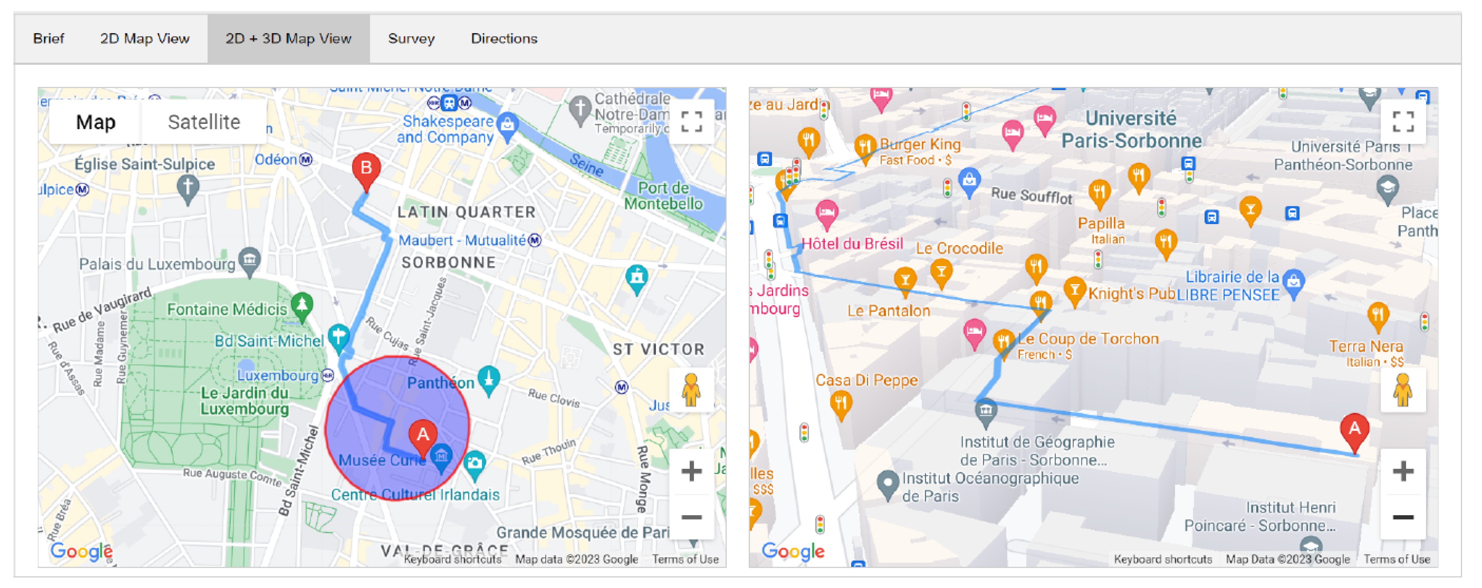
2D+3D map view
2D+3D map view
2D+3D map view
2D+3D map view
2D+3D map view
left-hand side displaying a similar 2D map
right-hand side displaying a 3D map showing the same route
Two map views side by side:
- left-hand side displaying a similar 2D map
- right-hand side displaying a 3D map showing the same route
Two map views side by side:
- left-hand side displaying a similar 2D map
- right-hand side displaying a 3D map showing the same route
Two map views side by side:
- left-hand side displaying a similar 2D map
- right-hand side displaying a 3D map showing the same route
Two map views side by side:
Interactive circular overlay
Interactive circular overlay
Interactive circular overlay
Interactive circular overlay
Interactive circular overlay
To overcome the challenges of redesigning eMBScope within a dynamic technical environment while respecting its legacy, we employed a dual-track UX strategy. This approach ensured both technical agility and user-centered evolution.
To overcome the challenges of redesigning eMBScope within a dynamic technical environment while respecting its legacy, we employed a dual-track UX strategy. This approach ensured both technical agility and user-centered evolution.
To overcome the challenges of redesigning eMBScope within a dynamic technical environment while respecting its legacy, we employed a dual-track UX strategy. This approach ensured both technical agility and user-centered evolution.
To overcome the challenges of redesigning eMBScope within a dynamic technical environment while respecting its legacy, we employed a dual-track UX strategy. This approach ensured both technical agility and user-centered evolution.
To overcome the challenges of redesigning eMBScope within a dynamic technical environment while respecting its legacy, we employed a dual-track UX strategy. This approach ensured both technical agility and user-centered evolution.
Appears on the 2D map when the user hovers over the route between point A and point B
It follows the cursor on the route as the user moves it
Appears on the 2D map when the user hovers over the route between point A and point B
It follows the cursor on the route as the user moves it
Appears on the 2D map when the user hovers over the route between point A and point B
It follows the cursor on the route as the user moves it
User Study
User Study
User Study
User Study
Observing Route Planning in Action : A Structured User Study
Observing Route Planning in Action : A Structured User Study
Observing Route Planning in Action : A Structured User Study
Observing Route Planning in Action : A Structured User Study
Observing Route Planning in Action : A Structured User Study
Six participants (three male, three female) from our HCI master's program\
21 to 26 years old
Have prior experience using navigation applications such as Google Maps, Apple Maps, etc.
Six participants (three male, three female) from our HCI master's program\
21 to 26 years old
Have prior experience using navigation applications such as Google Maps, Apple Maps, etc.
Procedure
Procedure
Procedure
Procedure
Getting Started
Getting Started
Getting Started
Getting Started
Getting Started
Informed consent form
Demographic information collected
Brief description of study
Training phase
Informed consent form
Demographic information collected
Brief description of study
Training phase
Challenges
Tasks
Tasks
Tasks
Tasks
Tasks
Two route planning and memorization tasks:
2D map view
2D + 3D map view
Users asked to recall the route and draw landmarks, street names, and the route on an empty paper
Asked to think-aloud in this process
Semi-structured interview
Two route planning and memorization tasks:
2D map view
2D + 3D map view
Users asked to recall the route and draw landmarks, street names, and the route on an empty paper
Asked to think-aloud in this process
Semi-structured interview
Challenges
Questionnaire
Questionnaire
Questionnaire
Questionnaire
Questionnaire
Questionnaire filled out by participants to gather information about their experience and preferences
Questionnaire filled out by participants to gather information about their experience and preferences
Questionnaire filled out by participants to gather information about their experience and preferences
Questionnaire filled out by participants to gather information about their experience and preferences
Questionnaire filled out by participants to gather information about their experience and preferences
Controlled Tasks with 2D and 2.5D Views
Controlled Tasks with 2D and 2.5D Views
Controlled Tasks with 2D and 2.5D Views
Controlled Tasks with 2D and 2.5D Views
Controlled Tasks with 2D and 2.5D Views


Data Analysis
Data Analysis
Data Analysis
Data Analysis
Data Analysis
From Observation to Themes
From Observation to Themes
From Observation to Themes
From Observation to Themes
From Observation to Themes
Data from structured observations was transcribed and analyzed using thematic analysis. Themes related to 2D versus 2D+3D map views were identified through a bottom-up approach. This involved generating codes from key quotes in the transcribed observations, followed by a collaborative process of organizing these codes into five overarching themes, categorized under two main sections.
Data from structured observations was transcribed and analyzed using thematic analysis. Themes related to 2D versus 2D+3D map views were identified through a bottom-up approach. This involved generating codes from key quotes in the transcribed observations, followed by a collaborative process of organizing these codes into five overarching themes, categorized under two main sections.
Data from structured observations was transcribed and analyzed using thematic analysis. Themes related to 2D versus 2D+3D map views were identified through a bottom-up approach. This involved generating codes from key quotes in the transcribed observations, followed by a collaborative process of organizing these codes into five overarching themes, categorized under two main sections.
Data from structured observations was transcribed and analyzed using thematic analysis. Themes related to 2D versus 2D+3D map views were identified through a bottom-up approach. This involved generating codes from key quotes in the transcribed observations, followed by a collaborative process of organizing these codes into five overarching themes, categorized under two main sections.

Results
Results
Results
Results
Results
Applying Thematic Analysis
Applying Thematic Analysis
Applying Thematic Analysis
Applying Thematic Analysis
Applying Thematic Analysis
The thematic analysis revealed key findings, which were organized into two primary categories: User Navigation Behavior and Map Interface Design.
The thematic analysis revealed key findings, which were organized into two primary categories: User Navigation Behavior and Map Interface Design.
User Navigation Behavior
User Navigation Behavior
User Navigation Behavior
User Navigation Behavior
User Navigation Behavior
The analysis of user navigation behavior centered on three key aspects: understanding how individuals recall and navigate routes, examining the role of landmarks and points of interest in route recall, and investigating user preferences between 2D and 2D+3D map views.
The analysis of user navigation behavior centered on three key aspects: understanding how individuals recall and navigate routes, examining the role of landmarks and points of interest in route recall, and investigating user preferences between 2D and 2D+3D map views.
The analysis of user navigation behavior centered on three key aspects: understanding how individuals recall and navigate routes, examining the role of landmarks and points of interest in route recall, and investigating user preferences between 2D and 2D+3D map views.
The analysis of user navigation behavior centered on three key aspects: understanding how individuals recall and navigate routes, examining the role of landmarks and points of interest in route recall, and investigating user preferences between 2D and 2D+3D map views.
The analysis of user navigation behavior centered on three key aspects: understanding how individuals recall and navigate routes, examining the role of landmarks and points of interest in route recall, and investigating user preferences between 2D and 2D+3D map views.
Memory and Recall
"I don't usually trust my memory and it's difficult for me to remember all the street names."
Memory and Recall
"I don't usually trust my memory and it's difficult for me to remember all the street names."
Memory and Recall
"I don't usually trust my memory and it's difficult for me to remember all the street names."
Memory and Recall
"I don't usually trust my memory and it's difficult for me to remember all the street names."
Landmarks and Points of Interest
"I find it easier to remember points of interest and landmarks and key points on the routes. Like for example, I remember there was a Starbucks here towards the first right."
Landmarks and Points of Interest
"I find it easier to remember points of interest and landmarks and key points on the routes. Like for example, I remember there was a Starbucks here towards the first right."
Landmarks and Points of Interest
"I find it easier to remember points of interest and landmarks and key points on the routes. Like for example, I remember there was a Starbucks here towards the first right."
Landmarks and Points of Interest
"I find it easier to remember points of interest and landmarks and key points on the routes. Like for example, I remember there was a Starbucks here towards the first right."
User Preference on Map Views
"I was stuck in the same angle of view in the 3D map. In the prototype, I could not rotate the point of view in the 3D map. So it would have been nice if I could rotate the camera/point of view on the 3D map view."usually trust my memory and it's difficult for me to remember all the street names."
Map Interface Design
Map Interface Design
Map Interface Design
Map Interface Design
Map Interface Design
The analysis of Map Interface Design focused on these key areas: understanding users' perceptions and interactions with the map interfaces, gathering feedback on the amount of information presented, and identifying user desires for customizable map features to enhance their experience.
The analysis of Map Interface Design focused on these key areas: understanding users' perceptions and interactions with the map interfaces, gathering feedback on the amount of information presented, and identifying user desires for customizable map features to enhance their experience.
The analysis of Map Interface Design focused on these key areas: understanding users' perceptions and interactions with the map interfaces, gathering feedback on the amount of information presented, and identifying user desires for customizable map features to enhance their experience.
The analysis of Map Interface Design focused on these key areas: understanding users' perceptions and interactions with the map interfaces, gathering feedback on the amount of information presented, and identifying user desires for customizable map features to enhance their experience.
The analysis of Map Interface Design focused on these key areas: understanding users' perceptions and interactions with the map interfaces, gathering feedback on the amount of information presented, and identifying user desires for customizable map features to enhance their experience.
Information Overload and Complexity
"I think there was too much information on the 3D map view. Too many icons and buildings and texts on the 3D map made it too complex and difficult to remember." | "switching focus between the 2D and 3D maps in the 2D+3D map view was overwhelming"
Information Overload and Complexity
"I think there was too much information on the 3D map view. Too many icons and buildings and texts on the 3D map made it too complex and difficult to remember." | "switching focus between the 2D and 3D maps in the 2D+3D map view was overwhelming"
Information Overload and Complexity
"I think there was too much information on the 3D map view. Too many icons and buildings and texts on the 3D map made it too complex and difficult to remember." | "switching focus between the 2D and 3D maps in the 2D+3D map view was overwhelming"
Information Overload and Complexity
"I think there was too much information on the 3D map view. Too many icons and buildings and texts on the 3D map made it too complex and difficult to remember." | "switching focus between the 2D and 3D maps in the 2D+3D map view was overwhelming"
Customization and Personalization
"I want to see only bus stops and maybe the RER symbols in 3D" | "I wish I could control how I go through the buildings in the 3D map" | "I found it difficult to relate to the buildings in the 3D view because they all looked the same grey."
Customization and Personalization
"I want to see only bus stops and maybe the RER symbols in 3D" | "I wish I could control how I go through the buildings in the 3D map" | "I found it difficult to relate to the buildings in the 3D view because they all looked the same grey."
Customization and Personalization
"I want to see only bus stops and maybe the RER symbols in 3D" | "I wish I could control how I go through the buildings in the 3D map" | "I found it difficult to relate to the buildings in the 3D view because they all looked the same grey."
Customization and Personalization
"I want to see only bus stops and maybe the RER symbols in 3D" | "I wish I could control how I go through the buildings in the 3D map" | "I found it difficult to relate to the buildings in the 3D view because they all looked the same grey."

Conclusion
Conclusion
Conclusion
Conclusion
Conclusion
Proposed Key Guidelines
Proposed Key Guidelines
Proposed Key Guidelines
Proposed Key Guidelines
The user study revealed that the 2D+3D map view approach did not significantly improve route planning and memorization compared to the traditional 2D map. Users generally found 2D maps more familiar and easier to use.
However, the 3D view was shown to enhance spatial learning and facilitate the formation of more accurate mental representations of the environment.
These findings underscore the importance of spatial learning and mental models in the design of map-based applications, and key takeaways were derived from the user study analysis.
✦
✦
✦
✦
✦
Streamline the display of information on maps
Streamline the display of information on maps
Streamline the display of information on maps
Streamline the display of information on maps
Streamline the display of information on maps
✦
✦
✦
✦
✦
Customize prominent features in 3D
Customize prominent features in 3D
Customize prominent features in 3D
Customize prominent features in 3D
Customize prominent features in 3D
✦
✦
✦
✦
✦
Provide more control over the point of view/camera in 3D
Provide more control over the point of view/camera in 3D
Provide more control over the point of view/camera in 3D
Provide more control over the point of view/camera in 3D
Provide more control over the point of view/camera in 3D
✦
✦
✦
✦
✦
Use more realistic models in 3D to enhance engagement and memorization
Use more realistic models in 3D to enhance engagement and memorization
Use more realistic models in 3D to enhance engagement and memorization
Use more realistic models in 3D to enhance engagement and memorization
Use more realistic models in 3D to enhance engagement and memorization
Want to explore some of my recent projects?
Want to explore some of my recent projects?
Want to explore some of my recent projects?
Want to explore some of my recent projects?
Want to explore some of my recent projects?
Human-centered Design.
Crafted With Care.
8:48 AM
Paris, France
© Anshul Singh Jadone. 2025.
Built with love and 24 cups of coffee.
Human-centered Design.
Crafted With Care.
8:48 AM
Paris, France
© Anshul Singh Jadone. 2025.
Built with love and 24 cups of coffee.
Human-centered Design.
Crafted With Care.
8:48 AM
Paris, France
© Anshul Singh Jadone. 2025.
Built with love and 24 cups of coffee.
Human-centered Design.
Crafted With Care.
8:48 AM
Paris, France
© Anshul Singh Jadone. 2025.
Built with love and 24 cups of coffee.
Human-centered Design.
Crafted With Care.
8:48 AM